Via Algarviana from Monchique to Sagres - Final Section
91.7km
8 days
Carefully Selected 0 to 0 star accommodations
easy
Starting From
€924
Jan
Feb
Mar
Apr
May
Jun
Jul
Aug
Sep
Oct
Nov
Dec
Popular Time
Good Time
Off/Low Season
Not Possible
This section of the walk will see you reach the highest point of the Algarve, Monchique before descending down to the coast through the arable landscape typical of the south-west of Portugal. As you near closer to end of the walk, you will find yourself winding your way along cliff tops to the most westerly point of the European continent, Cape St Vincent, and the Atlantic Ocean with its crashing waves and infinite skyline.
FREE This trip createstonne(s) of CO2, we offset it for free
Monchique to Sagres
Via Algarviana
From €924
Start Planning Now!
Services
Included in this package
Specially Hand-Picked Accommodations
Bed & Breakfast
24/7 On-Call Support
Dinners
Luggage Transfers from Hotel to Hotel
Roadbook
Add-On
Airport Transfer
Extra night stays
Not included
Flights/trains
Insurance
Drinks
Lunches
Itinerary
Day 1
Monchique
(Arrival
You will be met at Faro airport and transferred to your accommodation in Monchique, Bic Boa Guesthouse. Monchique is the highest town in the Algarve set in the dense woods of the Serra de Monchique mountain range. With traditional Algarvean houses, the narrow cobbled streets that criss-cross this town are perfect for wandering around and stopping for a coffee in one of the many cafes or perhaps a bite to eat in one of the restaurants. Be sure to also visit the main square where they have a water feature and an example of a Moorish water wheel.
Day 2 15km
Marmelete
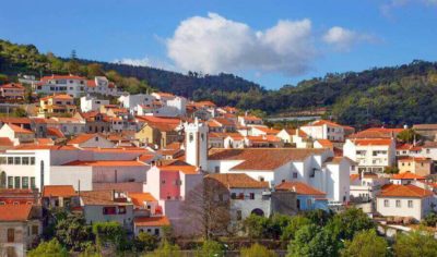
Starting out from Monchique today is a visit to the ruins of a 17th Century convent, Nossa Senhora de Desterro (Our Lady of Exile). Although a long steep climb up to this convent it is well worth it for the charm of what remains of this once beautiful building as well as the view of Monchique nestled in the surrounding forest. From here you will continue on the Via Algarviana, through a dense eucalyptus forest before emerging to a more rugged landscape that has fewer trees and more dense bushes and rocky outcrops allowing you to get sweeping views of this mountainous region. The antennas at Fóia mark the highest peak of the Serra de Monchique and although not on the Via Algravia are well worth a quick detour for the views and photo opportunities. Heading through the Penedo do Buraco ravine, pass a small dam and then down through a beautiful valley where animals graze and ancient agricultural terraces can still be seen, you soon reach Madrinha and pass through a wind farm. Continuing on through another eucalyptus forest you then have a steep climb to the popular viewpoint of Picos, before descending into Marmelete your stop for the night. This village has a thriving economy of cork harvesting, black pig farming as well as beekeeping for both its wax and honey. There is also a museum on the art of making Medronho “Firewater” that is worth a visit if you have the time.
Day 3 9km
Roundwalk in Marmelete
This walk starts in the centre of Marmelete, by its church. Initially following the Via Algarviana route through the town you then move north passing by the Santo António Chapel. Passing then through a cork oak forest you will come to Monte de Santo António and Covão where the surrounding trees will now be chestnut trees. Ascending then through eucalyptus grove you will reach the viewpoint of Picos with it panoramic views of the coast before returning to Marmelete.
Day 4 15km
Vale de Lobos
Leaving the Marmelete and the Serra de Monchique region the Via Algarviana descends down to the hamlet of Malhão and continues heading south. The landscape you are traversing today is very diverse with both Eucalpytus and Cork Oak forests, along with well-tended farms and small villages before coming to a wild unpopulated area, Romeiras, which presents an opportunity to stop and rest and get a bite to eat in the café. The walk to Corsino is relatively flat and there, you will get your first look at the Bravura Dam and the Odiáxere reservoir. As you follow the road around the reservoir a local sign will direct you to Vale de Lobos, you will be transferred from here to Bensafrim for the night and taken back the following morning to continue the walk.
Day 5 15km
Bensafirm
Passing through more Cork Oak and Holm Oak forests alongside quiet streams you will come into the fluvial valley before reaching Bensafrim. In the valley, the walk will now be across farms, vineyards, pastures and streams whilst continuing to head south. Crossing the Sobrosa steam several times just before Bensafirm the landscape changes again to open fields and limestone rock before arriving at this quaint country town. Bensafrim used to be an agrarian community that until the 1950’s the most popular means of transportation was by ox or donkey. More recently there has been an increase in development of this town, but you can still find restaurants that provide good quality local food that is great value!
Day 6 30km
Vila Do Bispo
From Bensafrim you will head to the town of Barão de São João. Firstly, you will be passing through the dense scrubland of Lavender, Cistus, False Pepper trees, among others. Coming upon a vast cork oak forest, which adds a depth of beauty to this area, you will then arrive into Barão de São João. Here you can get provisions for a picnic which you can enjoy in the local protected forest that you will be walking through next, “Perímetro Florestal do Barão de São João”, a Stone Pine forest that is the largest in the region. Passing then through an undulating mix of forest and more open areas until you reach Sesmarias which see the landscape change now to a large agricultural plateau. The trail here also passes through the important wetland of Budens’ fen, which is a treat for animal lovers as they can spot aquatic birds and even hear the croak of frogs in the spring. Descending, you will be surrounded by extensive grazing areas and agricultural fields welcoming you to the old farming heartland of the Algarve and Costa Vicentina. Entering the “Sudoeste Alentejano and Costa Vicentina” Natural Park you reach your destination for tonight, the appealing town of Vila do Bispo, which will give you your first glimpse of the Atlantic Ocean.
Day 7 17km
Cape St. Vincent
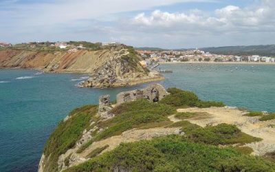
Setting out from Vila Do Bispo the remainder of the Via Algarviana is through the Natural Park, which is renowned for its beauty. The scenery is heavily influenced now by its proximity to the coast and if lucky you may get a sighting of some rare birds, indigenous to this area, the Red-billed Chough or Peregrine Falcon. Wandering over gentle hills of grain fields and grazing areas where cattle are a common sight you eventually join the Rota Vicentina. Passing by abandoned fields and joining the long-distance cycle path, “Ecovia do Litoral”, you will follow this all the way to Cape St Vincent. Arriving at Cape St Vincent, you are welcomed by the lighthouse which watches over one of the busiest shipping lanes in the world and has one of the most powerful lamps in Europe that is visible up to 60 km away. Surpassing the lighthouse, however, is the coastal panorama on this the most south-westerly point of not only Portugal but the European continent, and where the Romans believe the sun sank into the ocean marking the edge of the world. From Cape St. Vincent, you will then be transferred to Sagres where you are staying for the night. As with Cape St Vincent, this town has spectacular views of the sea and there are plenty of restaurants where you can enjoy a fabulous meal and well-deserved drink whilst watching the crimson sun set into the boundless Atlantic Ocean.


Share on