This itinerary allows you to walk the complete tour of Mont Blanc in comfort. We stand for providing you with the highest possible standard of accommodation around Mont Blanc while being truthful to the path and the walking interest. Accommodation may vary depending on the town where you’re staying; you’ll have a private room with a bathroom en suite, except for two nights where there is only a possibility for a shared bathroom. Dinners are included where there are no other options (for instance in Les Chapieux). In bigger towns, like Chamonix or Courmayeur, it is on a B&B basis.
FREE This trip createstonne(s) of CO2, we offset it for free
Chamonix - Start to Chamonix - End
Tour du Mont Blanc 12 days
From €1670
Preferred Month & Year
2026
2027
2028
Jan
Feb
Mar
Apr
May
Jun
Jul
Aug
Sep
Oct
Nov
Dec
Not Sure
Number of people
Additional Information / Request
Contact Informations
How should we contact you?
Enquire Now
Services
Included in this package
Specially chosen 2*/3* hotels or Auberges/Gites/Refuges
Bed & Breakfast
Dinners where it is specified in the itinerary
Luggage Transfer (except in some stages: refuges or gites inaccessible)
Roadbook (Guidebook)
24/7 Customer Care
Add-On
Transfer from/to airport
Additional Night
Premium Accommodation
Not included
Flights/trains
Insurance
Drinks
Small ground transfers
Itinerary
Day 1
Chamonix
(Arrival
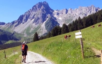
Located in the French Alps, Chamonix offers a true French European mountain experience with stunning hiking, old Savoyard culture and of course unforgettable views. Towering above Chamonix, Mont-Blanc is the tallest mountain in Europe reaching 4810m, 15,781ft. The views will blow you away.
Day 2 19km
Chamonix to Les Houches
High point: 2159m
Don’t worry, there are not many trails but only some and they are marked TMB. You are now ready to begin one of the most famous and impressive ascents all over the world for its legends. As soon as you leave Chamonix, wherever you are look up and you’ll see it there… 4,810 metres (15,781 ft) of rock, snow, ice and dreams of things to come.
Day 3 16km
Les Houches to Les Contamines
By TMB: 16km/5h15 By variante Châlet de Miage: 18km/7h30
High point: Col de Voza, 1653m or Col de Tricot, 2120m
Les Houches is located 6 kilometres from Chamonix. This charming village offers mountainsides with tree-lined slopes and impressive views of the Mont Blanc massif and the Chamonix valley. Just before reaching Col de la Voza, a row of Aiguilles that guard Mont Blanc offers themselves for inspection. The Dôme du Goûter and Aiguilles de Bionnassay then dominate views on the south side of the col, with the impressive Bionnassay glacier spilling between them, while from the hamlet of Le Champel the whole Val Montjoie is seen ahead with a hint of the Col du Bonhomme at its southern end.
Day 4 18km
Les Contamines to Les Chapieux
High point: Col de la Croix du Bonhomme, 2483m or Col des Fours, 2665m
At the foot of Mont-Blanc, discover a village quite unlike any other: tradition & authenticity. By tradition, we mean true alpine values, the respect of local architecture and the surrounding environment. By authentic we mean traditional buildings made of wood, stone and slate. At this stage, the TMB goes right to the head of Val Montjoie and crosses over into the Vallée des Glaciers by way of Col du Bonhomme. Early in the season snow will no doubt remain in patches between the two cols. At the end of this stage, you arrive in Les Chapieux, where you will find a relaxing atmosphere on a bend in the Vallée des Glaciers.
Day 5 28km
Les Chapieux to Courmayeur
Possibility of reducing the stage to 8h30 by using the local bus (from 1st July)
High point: Col de la Seigne, 2516m
At this stage, the TMB crosses out of France and enters Italy at the Col de la Seigne, one of the easiest crossings of the circuit, but one which also happens to be among the most scenic. Given reasonable visibility, the view of Mont Blanc and the Aiguille Noire from Col de la Seigne is stunning and is seen at its best early in the morning.
Day 6 12km
Courmayeur to Lavachey
By TMB: 12km/5h15 By variante Col Sapin: 18km/7h30
High point: 2023m
The beauty of the Italian side of the Mont Blanc is breathtaking all year round. Situated at the foot of the Italian side of Mont Blanc, Courmayeur, the Val Veny and Val Ferret are in summer popular with climbers, walkers, bikers and anglers. Nature, flora and fauna are intact. As in the Val d’Aosta, the breeding of cows is very present. Many herds of cattle and sheep also come to spend the summer pastures. The sound of bells will accompany your stay in these times so beautiful valleys. In good condition, this stage promises to be one of the highlights of the Tour of Mont-Blanc. The grandeur of yesterday’s view is matched on this stage along the flank of Mont de la Saxe where an easy, undulating path can be walked at leisure with eyes forever turning to the great wall of rock and ice across the Val Ferret. You could see the impressive and magnificent Grandes Jorasses on your way too.
Day 7 20km
Lavachey to La Fouly
High point: Grand Col Ferret, 2537m
The crossing of Grand col Ferret takes the TMB out of Italy, into Switzerland and along the eastern edge of the Mont Blanc range. Among the highlights of this stage will undoubtedly be the view from the col looking back, a view partly framed by monstrous buttresses of rock. In the Swiss Val Ferret, the way to La Fouly has other characteristics to enjoy: it has flower meadows and chalets with window boxes bursting with geraniums and petunia; it has milky streams, the clanging of cowbells, neat patches of forest and hamlets that appear to be untouched by passing centuries.
Day 8 15km
La Fouly to Champex
High point: Champex, 1466m
The small village La Fouly, situated in the Val Ferret in the Swiss canton of Valais sits at the foot of Mont Dolent (3,823m) and the Tour Noir (3,836m) in the Mont Blanc massif. This is the easiest stage of the TMB, and with a modest amount of height gain and loss, the day can be taken at a leisurely pace. Here we experience the pastoral nature of a Swiss mountain valley, where the way of life of the local farming communities appears at first glance to have been barely touched by modern technology.
Day 9 16km
Champex to Col de la Forclaz
By TMB: 16km/4h45 By Fenêtre d’Arpette: 14km/6h15
High point: Collet Portalo, 2040m or Fenêtre d’Arpette, 2665m
An idyllic retreat high up in the Swiss mountains, Champex is an ideal location to escape from the pressures of the modern world. Two charming places can be visited: Fort d’Artillerie, a fascinating underground fortress and Les Gorges du Durnand. It curves, dips, and rises over unsettled contours and in and out of indents in the hillside. There are neat meadows, patches of forest, rough combs and high alpine pastures leading to the simple alp buildings of Bovine. The Fenêtre d’Arpette, the highest point reached on the Tour of Mont Blanc, is a true mountain pass and one to enjoy for the sudden extraordinary vision of the upper Trient glacier revealed as you emerge through to the western side.
Day 10 15km
Col de la Forclaz to Argentiere
By TMB: 15km/6h By Refuge Les Grands: 20km/6h30
High point: Aiguillette des Posettes, 2201m or Col de Balme, 2191m
Col de la Forclaz marks the northern extent of the TMB, the furthest point from the summit of Mont Blanc, but this stage carries the route over the final mountain barrier and returns it to the Vallée de l’Arve, which flows at the foot of the Monarch of the Alps. Col de Balme, across which runs Franco-Swiss border, provides the first view, and the lovely snow dome remains in sight for most of the descent to Tré-le-Champ. This is achieved along the crest of the Aiguillette des Posettes, an elevated path with a large panorama.
Day 11 20km
Argentiere to Chamonix
By Les Praz-de-Chamonix: 20km/5h10 By Planpraz: 21km/5h20 By Alpages de Charlanon: 24km/6h
High point: Le Brévent, 2526m
Picturesque alpine walking and mountaineering village, Argentière is located near the head of the valley of Chamonix approximately 7 km from Chamonix town. The Argentière glacier lies to the south-east of the village and is bound on its north-east side by the Aiguille du Chardonnet, the Aiguille d’Argentière and the Tour Noir, and on its south-west by the Aiguille Verte, Les Droites and Les Courtes. The final stage of the Tour of Mont Blanc is as varied as any on this walk. It adopts the highly acclaimed Grand Balcon Sud, one of the most scenic of all alpine belvedere paths, which runs along the mid-height slopes on the north side of the Vallée de l’Arve to provide an almost uninterrupted panorama of the Mont Blanc range. At a junction of paths, you discover a cairn which marks a boundary of the Réserve Naturell des Aiguilles Rouges. Le Brévent, the altitude high point of this stage, offers a visual splendour of that lofty panorama remains as magical as ever.
Day 12
Chamonix
We can arrange extra nights anywhere on the itinerary after your last walking day. We can also arrange a station/airport transfer.
On the last week end of August (due to the UTMB), a supplement of €50 per night per person will apply for the night(s) in Chamonix. Also a transfer (included) will be arranged to an available hotel in one of the nearby towns.
Planpincieux glacier on Mont Blanc – Risk of Collapse – It has been reported that the Planpincieux Glacier may collapse, this glacier is located above the town of Courmayeur. Should this affect the route of the Tour Du Mont Blanc we will advise you accordingly.


Share on